Places to explore · Work and industry
Following the Lebanon glassworks landscape
Documented former works · Exact factory footprint unresolved
Brendan T. Byrne State Forest was once called Lebanon State Forest for a glassmaking settlement. A public trail preserves the name and gives walkers a route through the wider landscape, though it does not identify a furnace ruin.
A forest named for a works
Burlington County’s public history says Lebanon Glass Works opened in 1851 and closed in 1867 after its wood supply was depleted. An 1880 federal survey of glassmaking in New Jersey, drawing largely on glassmaker John T. Bodine’s recollections, lists Lebanon among works built in 1855 and later gone out of existence. The dates differ; the surviving accounts support a mid-century works without settling its exact opening year.
Glassmaking needed fuel as well as sand. The Pinelands Commission’s cultural resources plan explains how the region’s wood and silica-rich sands drew glasshouses into the Pines, and how fuel use altered the landscape. The county describes today’s forest as a striking change from the cleared nineteenth-century industrial setting. That contrast is the story a visitor can still read without locating a particular foundation.
A later trace in a fire report
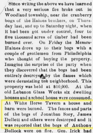
A New Jersey Mirror report of the May 1875 forest fire, preserved by the Tabernacle Historical Society, mentions losses at the old Lebanon Glass Works. Its use of “old” fits a site no longer operating as a glass factory, but the brief clipping does not inventory the buildings, prove the furnace survived until then, or give an exact footprint.
Walk the named route, not a guessed ruin
The State Park Service trail guide describes Glassworks Trail as an 8.4-mile green marked multiuse route, rated easy to moderate. It starts near the intersection of Lebanon Trail (Coopers Road) and Lebanon Road by the group camping area and restroom building. It follows sand roads through the southern forest, with some narrower paths. Its name connects a present walk to the former industry; the guide does not say that the route reaches a signed furnace, glasshouse wall or excavated town center.
For the visit, use the official forest map and check the current forest visitor page before setting out. The length makes this an outing to plan rather than a quick roadside stop. Stay on public marked routes and leave any historic material in place. A map pin belongs at a documented public arrival point or at forest scale, not on a speculative furnace location.
Sources and research limits
- Burlington County, Brendan T. Byrne State Forest — local public history and 1851–1867 chronology.
- U.S. Census Office, 1880 glassmaking survey, New Jersey section — independent nineteenth-century industry list, giving 1855 for Lebanon.
- Pinelands Commission, Cultural Resource Management Plan — regional glassmaking context and material demands.
- New Jersey Mirror, May 1875 fire report — mention of the old works, via preserved clipping.
- New Jersey State Park Service, Brendan T. Byrne trail guide and forest map — public route and access orientation.
The historical sources disagree on opening year, and none of the consulted official visitor maps identifies a factory footprint. The trail is presented as a landscape walk, not a ruin-finding route.